Bulgaria Ski discussion board
Snow forcassts
 Author:
posts : 13 (Beginner)Date : 10-25-08 00:52
Author:
posts : 13 (Beginner)Date : 10-25-08 00:52Snow forcassts
Hi Folks,Last time I went to Boro I kept my eye on the snow forcast and depth by using a very good link, problem is I cant remember its name. I'm pretty sure it was linked to this site, it showed the snow depth on the upper and lower slopes with a couple of sentances about the current weather and historical snow in Boro. Any of you know how I can find it again?
Cheers
Ad
re: Snow forcassts
thats a joke right thats the most unreliable site going try www.snowforecast.com
re: Snow forcassts
Best by farhttp://www.snow-forecast.com

re: Snow forcassts
oops left out the -
re: Snow forcassts
Another site for borovets weather forecasts is this one;http://www.metcheck.com/V40/UK/FREE/snow_forecast.asp?resortID=20
re: Snow forcassts
THis is ok for forecast but not snow depths.
re: Snow forcassts
theres this onehttp://www.skiresort.de/schneeberichte/schneewinter/schneeeu.htm
Shows snow depth, but not too reliable as I only up date it when I remember
 .......skiing takes preference
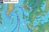
re: Snow forcassts
they are all inaccurate, based on averages and historical. Await forecasts from Benson and Hornster and the odd one from me as the season gets going. Professional data is used and not 'lets have a guess' attitude as most of the web sites !re: Snow forcassts
We need to remember that it is still October and although we may see the odd flurry at this time of year it isn't until at least mid to late December that we can expect those long spells of snowfalls with sub zero temperatures that is necessary to create the sub-base for the snowpack to build up during the season. If the sub-base is decent then even light snowfalls will be enough to transform that days skiing. The ideal is for a good amount of early season snowfall with temperatures hovering ...
We need to remember that it is still October and although we may see the odd flurry at this time of year it isn't until at least mid to late December that we can expect those long spells of snowfalls with sub zero temperatures that is necessary to create the sub-base for the snowpack to build up during the season. If the sub-base is decent then even light snowfalls will be enough to transform that days skiing. The ideal is for a good amount of early season snowfall with temperatures hovering around zero and sub-zero. That way any snow that falls early on should remain, creating the type of sub-base that we all hope for.